
OpenCPN, selon Shoreline
OpenCPN, selon Shoreline |
| Plan du
site ---> Dossiers techniques
---> Fichiers GPX : Marques et waypoint |
| DT_23 | Marques et waypoint : leurs formats dans un fichier GPX |
| Validité : 4.2 |
 |
<?xml
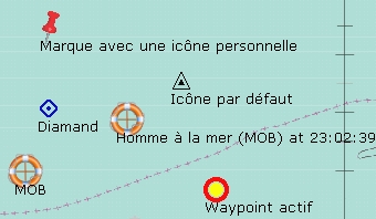
version="1.0" encoding="utf-8" ?> <gpx version="1.1" creator="OpenCPN" xmlns:xsi="http://www.w3.org/2001/XMLSchema-instance" xmlns="http://www.topografix.com/GPX/1/1" xmlns:gpxx="http://www.garmin.com/xmlschemas/GpxExtensions/v3" xsi:schemaLocation="http://www.topografix.com/GPX/1/1 http://www.topografix.com/GPX/1/1/gpx.xsd" xmlns:opencpn="http://www.opencpn.org"> <wpt lat="49.276095000" lon="-4.573030000"> <time>2013-01-06T22:04:23Z</time> <name>Waypoint actif</name> <sym>activepoint</sym> <type>WPT</type> <extensions> <opencpn:guid>545affff-0c88-451a-a126-4c840b3e0000</opencpn:guid> <opencpn:viz>1</opencpn:viz> <opencpn:viz_name>1</opencpn:viz_name> </extensions> </wpt> </gpx> <?xml version="1.0" encoding="utf-8" ?> <gpx version="1.1" creator="OpenCPN" xmlns:xsi="http://www.w3.org/2001/XMLSchema-instance" xmlns="http://www.topografix.com/GPX/1/1" xmlns:gpxx="http://www.garmin.com/xmlschemas/GpxExtensions/v3" xsi:schemaLocation="http://www.topografix.com/GPX/1/1 http://www.topografix.com/GPX/1/1/gpx.xsd" xmlns:opencpn="http://www.opencpn.org"> <wpt lat="58.962540000" lon="18.579370000"> <time>2013-01-06T21:15:02Z</time> <name>Carte Suède</name> <sym>Marker - Punaise Red</sym> <type>WPT</type> <extensions> <opencpn:guid>15e40000-ea15-4ce1-8964-d6692f340000</opencpn:guid> <opencpn:viz>1</opencpn:viz> <opencpn:viz_name>1</opencpn:viz_name> </extensions> </wpt> <wpt lat="49.589098609" lon="-4.725275510"> <time>2013-01-06T22:01:02Z</time> <name>Icône par défaut</name> <sym>triangle</sym> <type>WPT</type> <extensions> <opencpn:guid>7878ffff-fb55-4e9f-ad98-91570d910000</opencpn:guid> <opencpn:viz>1</opencpn:viz> <opencpn:viz_name>1</opencpn:viz_name> </extensions> </wpt> <wpt lat="49.509440701" lon="-5.314612217"> <time>2013-01-06T22:01:07Z</time> <name>Diamand</name> <sym>diamond</sym> <type>WPT</type> <extensions> <opencpn:guid>7a56ffff-01a6-42c7-a8b7-16fe2fc40000</opencpn:guid> <opencpn:viz>1</opencpn:viz> <opencpn:viz_name>1</opencpn:viz_name> </extensions> </wpt> <wpt lat="49.327335000" lon="-5.417746667"> <time>2013-01-06T22:01:44Z</time> <name>MOB</name> <sym>mob</sym> <type>WPT</type> <extensions> <opencpn:guid>64a7ffff-bbef-49bd-a752-fbb30cce0000</opencpn:guid> <opencpn:viz>1</opencpn:viz> <opencpn:viz_name>1</opencpn:viz_name> </extensions> </wpt> <wpt lat="49.477541163" lon="-4.965921332"> <time>2013-01-06T22:02:39Z</time> <name>Homme à la mer (MOB) at 23:02:39</name> <sym>mob</sym> <type>WPT</type> <extensions> <opencpn:guid>4a6dffff-ab4d-4161-ac1c-9c0b5cb0ffff</opencpn:guid> <opencpn:viz>1</opencpn:viz> <opencpn:viz_name>1</opencpn:viz_name> <opencpn:shared>1</opencpn:shared> </extensions> </wpt> <wpt lat="49.741677803" lon="-5.304789939"> <time>2013-01-06T22:02:57Z</time> <name>Marque avec une icône personnelle</name> <sym>Marker - Punaise Red</sym> <type>WPT</type> <extensions> <opencpn:guid>2cc70000-a3e1-4a3f-b58d-991d2b790000</opencpn:guid> <opencpn:viz>1</opencpn:viz> <opencpn:viz_name>1</opencpn:viz_name> </extensions> </wpt> <wpt lat="49.276095000" lon="-4.573030000"> <time>2013-01-06T22:04:23Z</time> <name>Waypoint actif</name> <sym>activepoint</sym> <type>WPT</type> <extensions> <opencpn:guid>545affff-0c88-451a-a126-4c840b3e0000</opencpn:guid> <opencpn:viz>1</opencpn:viz> <opencpn:viz_name>1</opencpn:viz_name> </extensions> </wpt> </gpx> |
Up Up Up Up |
|
||
| Comment obtient-on un fichier GPX ?
On y repère plusieurs parties :
Remarque :
|
| Aller au Tutoriel_PC.htm | |
| Retour haut de page |
| Copyright
: Ce site web est protégé contre toute utilisation
commerciale. Dernière modification de cette page : |